
Support Hidden Compass
Our articles are crafted by humans (not generative AI). Support Team Human with a contribution!
Entering an opaque cloud, I crunched across a flat expanse of shallow snow, unsure of what awaited on the other side. Thick fog braided itself through the branches of the forest. A piney aroma danced in my nose. The humidity was palpable, like cool watermelon brushing the roof of my mouth. The low hum of a ski lift reverberated through the woodland’s deep calm.
After 40 feet or so, the heavy mist lifted, a theatrical curtain pulled back. Tingles prickled my toes and fingertips, and my lips broke into a grin.
A pristine slope — steep and blanketed with fluffy powder — unspooled below my snowboard. I dug in my heels and, without hesitation, set off down the mountain. Carving a zigzag through dense crystals, I announced my descent to the hemlocks with a yelp. “Yeeeeeww!”
In a flurry of adrenaline, I followed one of the largest cumulative snowpacks in North America into the unfamiliar.
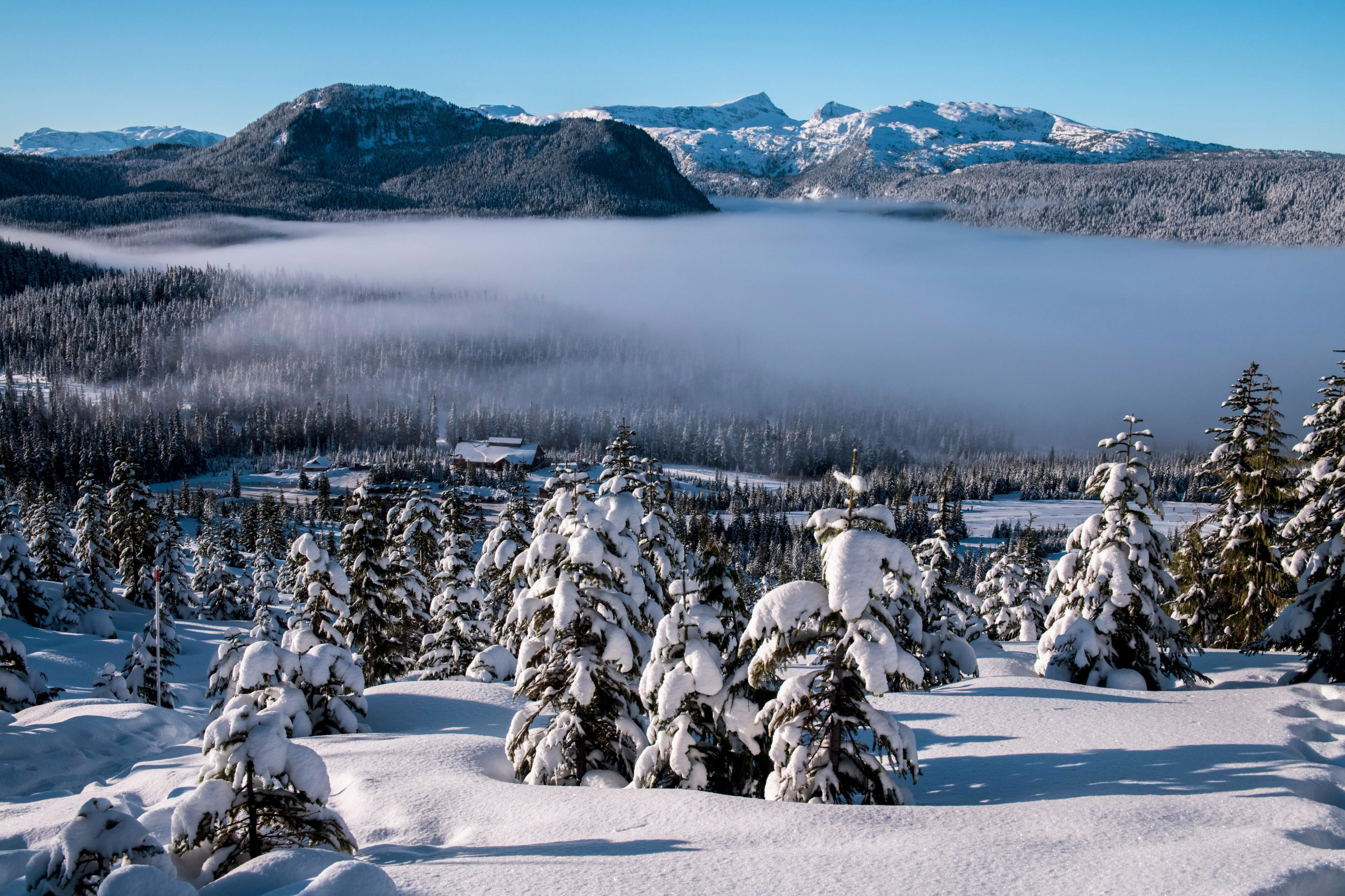
A layer of fog often cloaks the snow-frosted landscape of Mount Washington Alpine Resort. Coastal Vancouver Island is known for unique atmospheric conditions, including fogbows — a muted cousin of the rainbow. Photo: Dave Hutchison/Alamy.
~~
I had found my way to the dazzling white crest of Vancouver Island’s Mount Washington Alpine Resort on this January afternoon to immerse myself in an ancient and spectacular environment. Snowy landscapes like this feel like home to me, a backcountry snowboarder from Colorado’s Western Slope. But it’s more than superlative powder that brought me here.
I wanted to move through this terrain like a river — weaving down its frozen slopes and rushing to its rugged shores. I would begin in the snowpack and end in the sea.
But not all rivers flow in the way that we predict. They shift course, at times suddenly, branching off from what’s expected. Sometimes they bring sustenance. Other times, they wreak havoc.
~~
Like in so many places across our planet, Mount Washington is trending warmer than usual. In 2019, the resort instated its first snowmaking machine.
Since the 1970s, Vancouver Island’s glacier count has reduced from 170 to five. Some scientists anticipate the remaining glaciers will melt in less than 25 years. As climate change reshapes British Columbia, its snow culture is losing steam. Many resorts at lower elevations have already shuttered. Forbidden Plateau, eight miles south, closed in 1999 after years of poor conditions, capped off by heavy snow that collapsed the roof of the day lodge. Southeast of here, across the Salish Sea, Cypress Mountain faces increasingly mediocre seasons. West Vancouver’s Hollyburn Chairlift, which burned in 1965, would be inoperable now due to insufficient snowfall.
Though I’m not from here, I understand what a profound loss this is. Snow culture has shaped several generations of my family. I learned to walk in the white-capped mountains of Telluride and started snowboarding as a kid. Moving across wintry terrain comes naturally to me. It’s my first language.
I wanted to move through this terrain like a river — weaving down its frozen slopes and rushing to its rugged shores. I would begin in the snowpack and end in the sea.
I’m only 29. It’s difficult for me to picture these coastal peaks, and those of my beloved Rockies, not covered in snow. The ripple effects caused by that level of thaw are even more unimaginable.
On a global level, I worry about rising seas and water insecurity, extreme avalanche cycles and endless droughts. But I also wonder what turbulence our identities will be forced to withstand. How do we prepare for the change of something so fundamental?
~~
Seven miles away, later that winter, Bill Floyd pulled the skin taut on his right ski and dropped it into the snow. The slope in front of him glinted in the sun, a positive omen in this often cloudy coastal mountain environment. All around, piles of snow frosted the dark green branches of the Western red cedar and Douglas firs.
Like me, Floyd worries about what gets lost as the snow melts, a concern he quantifies as data. A former hockey player, he took his passion for snow and ice and carved it into a career as a research hydrologist for the province of British Columbia. In his field, snowpack is a metric of survival — insurance for the island’s water supply.
Floyd pushed forward on his skis, one by one, listening to the smoosh-smoosh beneath each step and marveling at the mild winter temperatures, around 32 degrees Fahrenheit. “I’m dropping a layer,” he said, his full cheeks magnifying his bright smile, as he paused to spread sunscreen across the tops of his hands.
Earlier that morning, a helicopter had deposited him and a crew of five other scientists here below the cragged summit of Castlecrag Mountain in Strathcona Provincial Park, a vast wilderness stretching from the edge of Mount Washington Alpine Resort nearly to Tofino. Every few weeks in the winter, Floyd and his team strap on skis and backpacks full of equipment and supplies and head into the Vancouver Island backcountry to measure snowpack.
Known as the Cruickshank watershed, this landscape straddling some of the island’s tallest peaks offers a case study in snow research — as it is influenced by human footprint as well as the ecology of streams that flow through. Receiving rain, snow, and glacial melt, the Cruickshank River feeds into Comox Lake, which in turn provides hydroelectric power and drinking water for Vancouver Island’s third-largest population to the east.
Cruickshank is also one of the sites of the Hakai Cryosphere Node, a $2.4-million-plus research project to track seasonal and annual changes in British Columbia. For scientists like Floyd, keeping tabs on the island’s snowpack helps plot a course through the shifting atmosphere.
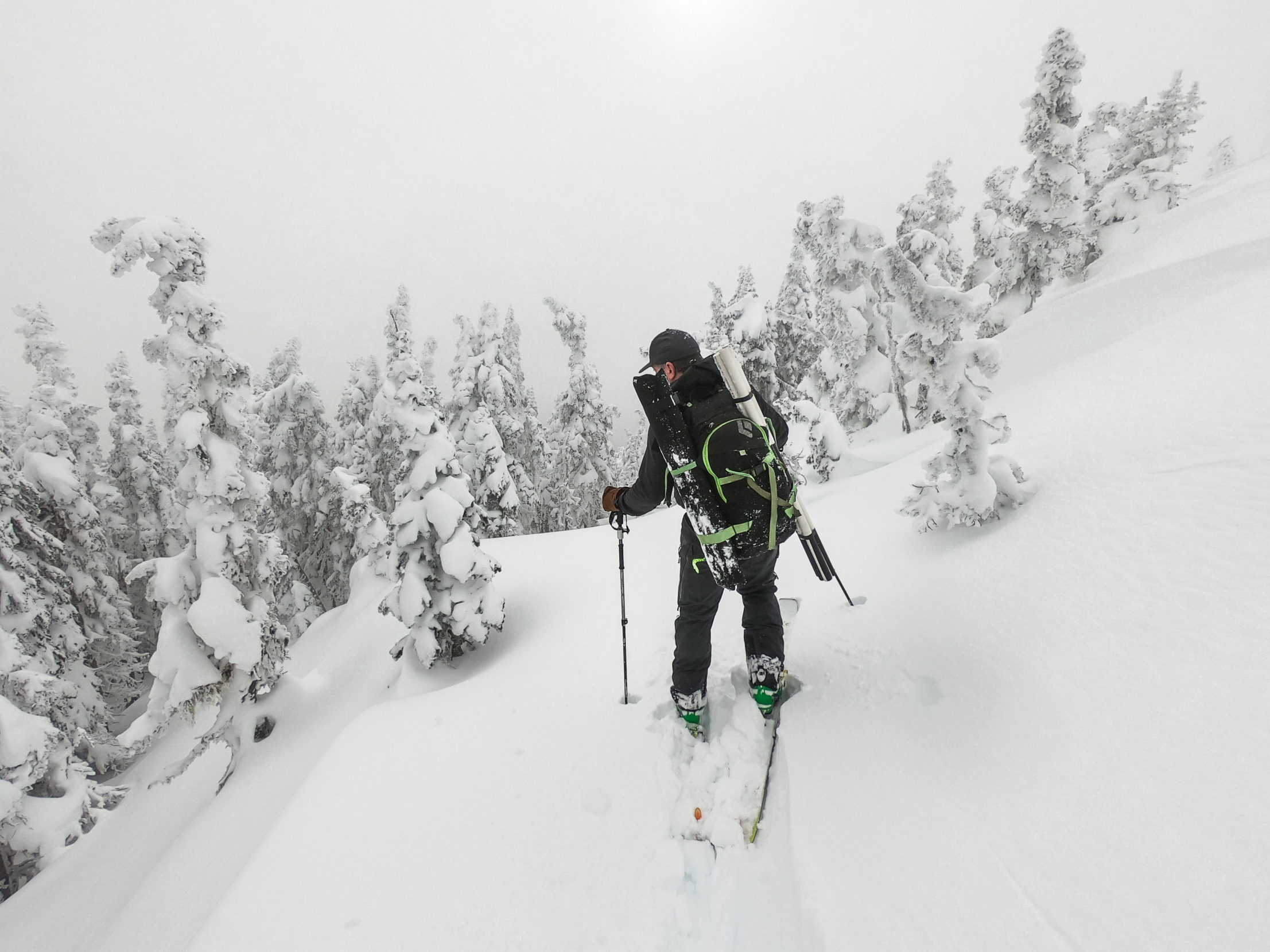
Loaded with gear to measure snowpack, research hydrologist Bill Floyd ventures into the British Columbia backcountry. Fieldwork is a perk of the job for this avid skier who otherwise spends his days in the lab or teaching geography at Vancouver Island University. Photo: Will McInnes.
~~
A three-hour drive later, with the snowy slopes in my rear mirror, I arrived on the bowed beach of Cox Bay, one of Tofino’s surfing spots. These shores are known for some of the continent’s most consistent surf breaks. Golden light illuminated the spindrift above the ocean, casting an ethereal glow above the foamy whitewater. A handful of surfers rode out the day’s light.
So extreme are its atmospheric conditions, this coast draws storm-watchers from around the world to stand in awe of the tumultuous sea.
Rows of unbroken crests continued as far as I could see. A wave landed and slid up the cove toward the soles of my boots. Squish, squish. I slipped off my boots and sunk my toes into the velvety embrace of the cold, wet sand.
Tomorrow I would return to surf, but first I hoped to prepare my mind. I’ve spent my whole life as an inlander, and nothing about the ocean feels intuitive. Reading the water, and moving with it, would require my full attention. Especially here, where winter storms, born far out across the ocean, crash on the rocks with wild fury. Swells occasionally top 20 feet. So extreme are its atmospheric conditions, this coast draws storm-watchers from around the world to stand in awe of the tumultuous sea.
I strolled the length of the shore, breathing in the salty air and willing the pounding surf to wash away the doubts bubbling up in my mind. As the bottom third of the sun disappeared below the ocean’s brink, its billows merged with a sweep of tangerine and plum above.
Becoming one with the waves is all about surrendering to the moment, and to your immediate surroundings. But if you want to stay above the break, you can never take your eye off what’s brewing in the distance.
~~
Back in the mountainous backcountry, Floyd scanned the sky. Nothing yet. The sun rose over Moat Lake, below their tented base camp. After a hearty breakfast cooked over a wood-burning stove in a nearby cabin, he and his team of five had split into two groups to divide and conquer the day’s data goals.
As they crunched across the glistening terrain, Floyd kept his gaze high, anxious. “I hope the pilot and technician are on their way,” he said, eyeing a handful of clouds to the west.
On this day, Floyd was counting on help from above — 15,000 feet above — to capture the full picture of the snowpack. Using lidar, a remote sensing method, a fixed-wing aircraft would shoot out a pulsed laser to measure distances to Earth’s surface. But this groundbreaking technology, largely funded by the cryosphere node, works best on sunny days.
Near the summit of Mount Frink, Floyd stomped out a flat area with his skis. A team member got to work setting up the R2-D2-like GPS rover and roping out a circle just over 60 feet across, a diameter about as long as a bowling lane.
Entering an opaque cloud, I crunched across a flat expanse of shallow snow, unsure of what awaited on the other side.
Floyd pulled out a hollow aluminum tube and placed its jagged end into the snow. Using a wrench, he began screwing it through the icebound crust. After several minutes, his abdominal muscles strained from the effort, but he still hadn’t felt the bite of the soil underneath. Nearby, a colleague called out a 12-foot depth, which Floyd scribbled on a notepad.
He helped his teammate balance the full tube on a hanging scale, the pair like proud fishermen with a big catch. The weight of the snow core would allow them to calculate the density and amount of water held in the snowpack.
Leapfrogging with their instruments in a dance over the snow, the researchers repeated this pattern for a couple of hours, until they achieved five density measurements and 32 depth measurements throughout the plot. As long as the snow didn’t ice up due to the warming sun, their snow tube wouldn’t get clogged and they could complete their session in time to move higher on the ridge, to 6,867-foot Albert Edward.
For the past century, scientists have measured snowpack in much this same way. But the adoption of remote sensing adds an exponential number of data points to snowpack assessment. In a single sweep, lidar could collect as many as 1,200 depth measurements in this roped-off plot — and some 4 million data points across the Cruickshank watershed, compared to 400 measurements taken by hand over two long days of fieldwork by Floyd and his colleagues.
“While these tools won’t solve climate change, they will allow us to adapt better and become more resilient.” —Bill Floyd
As sweat dripped down his temples into his beard, Floyd took a moment to gaze northeast across the valley toward Mount Washington Alpine Resort, in the distance. He inhaled a deep breath, rotated the snow tube downward for the second sample, and — to his relief — heard the plane fly overhead.
~~
On my first morning in Tofino, icy droplets seeped into my booties as I stepped from the soft shelf of sand into the Pacific. The water in my thick wetsuit quickly warmed to my body temperature. I slowly exhaled and walked toward the waves, my surfboard balanced beside me.
At thigh depth, I hopped up and slid my stomach across the board. Just then, a sudsy wave crashed against the board’s nose, stinging my lips with salt. Swoo-splash — the thundering waves sounded fierce. Strong but not violent, I reminded myself.
My gaze extended out to the rocky coastline — and the ominous clouds that had started forming in the distance.
How much warning does a storm give, as it approaches the coast?
~~
Southwest of Vancouver Island, on an otherwise ordinary January day, a stunning disturbance developed several miles above Earth’s surface. A warm, moist cylinder of air, northbound from the tropics, spearheaded the jet stream; a column of cold air blasted from the other side; dry air plummeted from above. This trio of air streams coalesced into a single mighty point, intensified by a counterclockwise wind.
Satellites showed a swirling nautilus shell known as an extratropical cyclone, an important force shifting rain and snow showers around much of the planet. But along the cyclone’s northern periphery, a ribbon of rapid air got caught ahead of the cold front, and a tentacle of condensed water vapor surged towards the west coast of North America.
This jet stream of moisture is called an atmospheric river and can transport up to 15 times the volume of water that passes through the mouth of the Mississippi River. Coupled with high winds, the vigorous flow can stretch more than 1,000 miles long, 300 miles wide, and two miles deep.
With immense speed, this powerful phenomenon was on a collision course with the rugged peaks of the Vancouver Island Ranges.
~~
Several weeks after his fieldwork in the mountains, Floyd sat in his climate-controlled lab on the Nanaimo campus of Vancouver Island University. As he compared the snow-depth models created by the measurements his team had gathered by hand and those from the lidar flights, he sighed in relief. The models aligned within a few inches, close enough that he could dive into the results with confidence.
This merging of new technology and decades-old processes thrills Floyd. The data gives him and his colleagues a chance to better understand and plan for intense weather events, such as the increasingly strong and destructive storms hitting British Columbia in recent years.
“While these tools won’t solve climate change,” Floyd told me, “they will allow us to adapt better and become more resilient.”
Because even as he tinkered with his computations, projecting how much drinking water would be available later in the year and where it was stored, he couldn’t be certain of what might roll in from the atmosphere to wipe out the island’s snowpack.
~~
As the river in the sky charged above the coast of British Columbia and Vancouver Island, the current swept over the mountains and the moisture cooled — allowing the heavy load to suddenly drop. Over the next 48 hours, extreme rain pummeled what lay below, up to seven inches in some areas.
This jet stream of moisture is called an atmospheric river and can transport up to 15 times the volume of water that passes through the mouth of the Mississippi River.
Water hosed the forest tops and rushed down hillsides, pulling rocks, twigs, trees, and mud to lower ground. Breakneck floods carved their way through the mountain slopes and gullies to the roadways, transforming the strips of tar to rivers themselves, and filling farm fields. The heavy rains liberally flushed out logged hillsides, adding turbidity to the surrounding creeks and smothering salmon eggs with sediment.
Every drop raised the levels of rivers and streams, accelerated flows, destabilized banks. Excavation sites and power lines collapsed. Water mains burst. Recreation trails were washed out.
Water rushed out of manhole covers in the center of bustling intersections during rush hour. The pavement flooded with pools deep enough for hydroplaning. Infrastructure was damaged, making water impotable. Drivers were stranded in vehicles, or trailer homes, due to high flood waters.
As freezing levels jumped above 6,000 feet in altitude, rain doused Mount Washington and all its ski runs — in the process obliterating a significant portion of the snowpack.
I marveled at the sheer force of the storm from back home in Colorado — and by my good timing. The atmospheric river had missed me by four days. By a stroke of luck, our paths had diverged.
~~
Days earlier, on the final morning of my trip, knobby roots pushed into the foot soles of my wetsuit as I walked on a dirt path that tunneled through the rain forest, heading to the north end of Chesterman Beach for one more surf session. When I reached the sand, I set down my board and sat on a log.
The storm clouds I had spotted the day before had rolled on without incident. My nerves had dissipated in the water. I had found a rhythm paddling against the waves and then riding back to shore, each time more confident than the last. For a few hours, I had begun to speak the language of the sea.
I don’t know what the coming decades hold for the snowy peaks I love, or whether surfing will ever feel intuitive. But just as water holds the power to shape a landscape as varied as Vancouver Island, forces of nature change us over time, too. Learning to surf has taught me to resist the urge to fight every shift in my environment.
Scientists like Floyd also know that fluidity builds resiliency. Emerging technology and other advances on the horizon offer more than a silver living in the coming storm. Adaptation offers new paths forward.
But just as water holds the power to shape a landscape as varied as Vancouver Island, forces of nature change us over time, too.
A wave lapped up against my shins. I looked across the navy blue ocean and smiled, remembering a story I had heard about this radiant place, one sure to compel me to return some day. Sometimes snow covers the sand here, falling as you surf, as the freezing air kisses your cheeks.
In those fleeting moments, worlds converge unexpectedly. They can invite us into the unknown — and it’s spectacular.
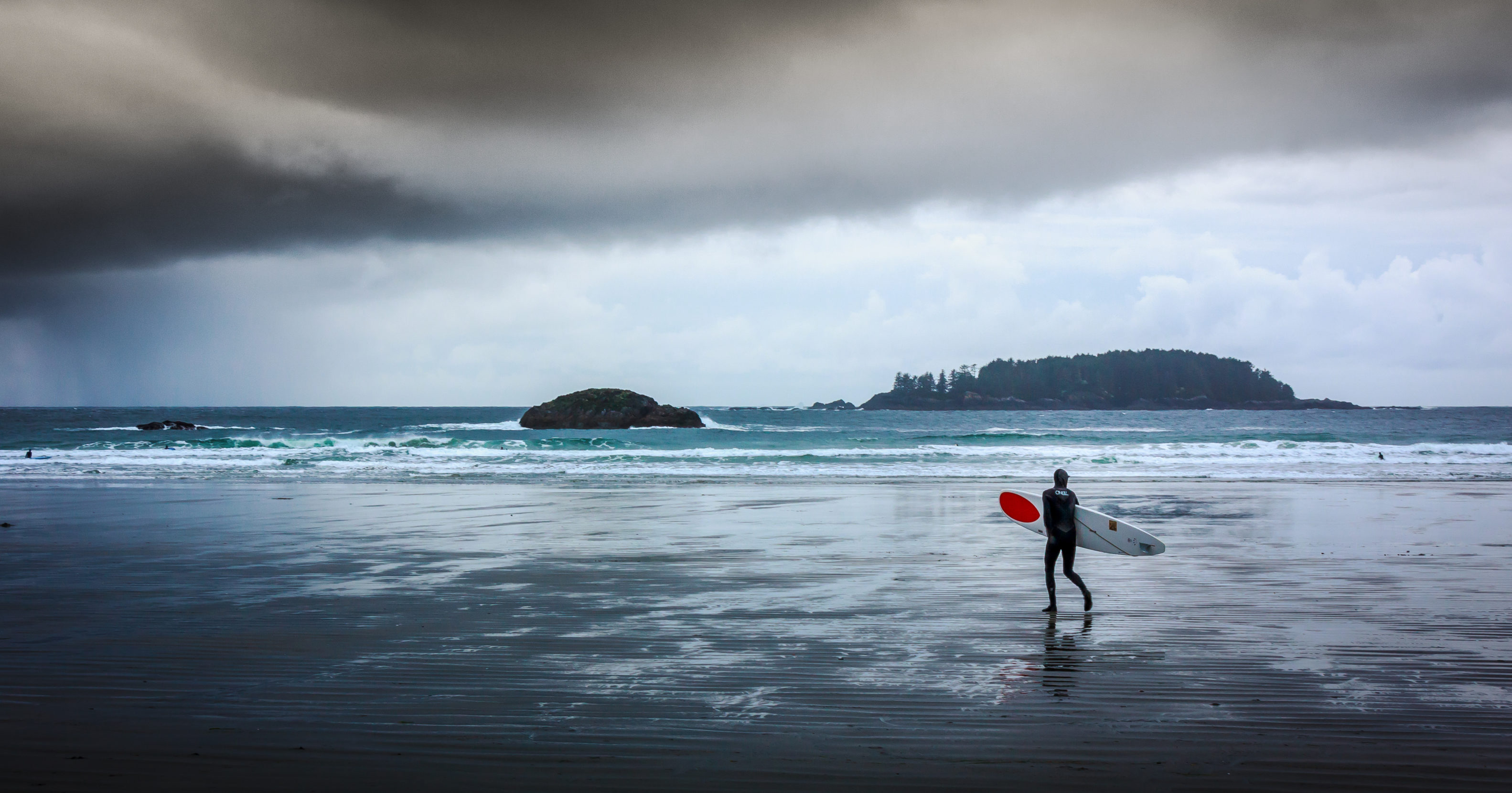
A lone surfer approaches a coming storm on a Tofino beach. Dramatic skies and storm swells converge on the west coast of Vancouver Island each winter. Photo: Craig Whiteside.
Morgan Tilton
Molded and catalyzed by natural environments, Morgan Tilton is a creative writer and reporter fueled by snowfall, shooting stars, and Nuun hydration tablets. She specializes in outdoor industry news, adventure travel, and stories of human endurance.